Difference between revisions of "Time"
m (→GPS: The Global Positioning System) |
m (→GPS: The Global Positioning System) |
||
| Line 108: | Line 108: | ||
[http://www.youtube.com/results?search_query=GPS+Global+Positioning+GNSS+clock+time+keeping+artificial+intelligence+ai YouTube search...] | [http://www.youtube.com/results?search_query=GPS+Global+Positioning+GNSS+clock+time+keeping+artificial+intelligence+ai YouTube search...] | ||
[http://www.google.com/search?q=GPS+Global+Positioning+GNSS+clock+time+keeping+artificial+intelligence+ai ...Google search] | [http://www.google.com/search?q=GPS+Global+Positioning+GNSS+clock+time+keeping+artificial+intelligence+ai ...Google search] | ||
| − | |||
* [[Space/Planets#Man-made (artificial) Satellites|Man-made (artificial) Satellites]] | * [[Space/Planets#Man-made (artificial) Satellites|Man-made (artificial) Satellites]] | ||
| Line 144: | Line 143: | ||
|} | |} | ||
|}<!-- B --> | |}<!-- B --> | ||
| − | |||
| − | |||
| − | |||
| − | |||
| − | |||
| − | |||
| − | |||
| − | |||
| − | |||
| − | |||
{|<!-- T --> | {|<!-- T --> | ||
| valign="top" | | | valign="top" | | ||
| Line 159: | Line 148: | ||
|| | || | ||
<youtube>8eTlI19_57g</youtube> | <youtube>8eTlI19_57g</youtube> | ||
| − | <b> | + | <b>GPS, How does it work? | ICT #12 |
| − | </b><br> | + | </b><br>GPS has already become an integral part of our lives, and you can see a few useful applications from these examples. GPS is really an interesting technology. It uses a system of 24 satellites continuously orbiting the earth, and requires at least four satellites to track your location; it uses an atomic clock, and the time error of your mobile phone is also a matter of great concern. Moreover, Albert Einstein’s theory of relativity plays an important role in GPS technology, finally, a real-life application for the theory of relativity! Let’s put aside all these complications and understand the technology of GPS in a step by step and logical manner. Be a Learn Engineering supporter or contributor: http://www.youtube.com/channel/UCqZQ... |
|} | |} | ||
|<!-- M --> | |<!-- M --> | ||
| Line 167: | Line 156: | ||
|| | || | ||
<youtube>ySr4eepUVqI</youtube> | <youtube>ySr4eepUVqI</youtube> | ||
| − | <b> | + | <b>MIT's AI System helps to improve GPS navigation in places with limited map data | RoadTagger |
| − | </b><br> | + | </b><br>Rajamanickam Antonimuthu An AI model developed at MIT and Qatar Computing Research Institute uses only satellite imagery to automatically tag road features in digital maps. This innovation could improve GPS navigation, especially in countries with limited map data. |
|} | |} | ||
|}<!-- B --> | |}<!-- B --> | ||
| Line 176: | Line 165: | ||
|| | || | ||
<youtube>-g3sW40o4TU</youtube> | <youtube>-g3sW40o4TU</youtube> | ||
| − | <b> | + | <b>GPS vs AI: The Challenges of Losing Satellite Signal | Roborace |
| − | </b><br> | + | </b><br>How do trees affect satellite and GPS acquisition during a Roborace test run? #Education #Roborace #AutonomousVehicles Trees have a detrimental effect on the GPS and Satellite system for the DevBot 2.0, as it is one of the most important factors for autonomous racing. Roborace is the world’s first competition for human + machine teams, using both self-driving and manually-controlled cars. Race formats will feature new forms of immersive entertainment to engage the next generation of racing fans. Through sport, innovations in machine-driven technologies will be accelerated. Roborace will redefine the way you think about autonomous technology. To be a part of our autonomous journey, subscribe to our channel: http://goo.gl/TNbPAB |
|} | |} | ||
|<!-- M --> | |<!-- M --> | ||
| Line 184: | Line 173: | ||
|| | || | ||
<youtube>HiFW2d2gvt8</youtube> | <youtube>HiFW2d2gvt8</youtube> | ||
| − | <b> | + | <b>Why GPS wouldn't work if we didn't know about relativity |
| − | </b><br> | + | </b><br>One technology you probably use everyday that wouldn't work if it wasn't for Einstein's theories is GPS, or the global positioning system. |
|} | |} | ||
|}<!-- B --> | |}<!-- B --> | ||
| Line 193: | Line 182: | ||
|| | || | ||
<youtube>GrKtsafA2UU</youtube> | <youtube>GrKtsafA2UU</youtube> | ||
| − | <b> | + | <b>A9G GPS & GPRS Module Tutorial | Ai-Thinker | AT Commands |
| − | </b><br> | + | </b><br>PCBWAY: http://www.pcbway.com/ Wanna help us out? [http://github.com/akarsh98/A9G-Supporting-material GitHub] Consider donating any amount: http://www.paypal.me/akarsh98 CETech@FB: http://www.facebook.com/CETech4u/ Our email: akarshagarwal98@gmail.com Track: Raiko - Revenger [NCS Release] Music provided by NoCopyrightSounds. Watch: http://youtu.be/Vj_V0RfdTSY Free Download / Stream: http://ncs.io/Revenger |
|} | |} | ||
|<!-- M --> | |<!-- M --> | ||
| Line 201: | Line 190: | ||
|| | || | ||
<youtube>xwO7G8Iu_f4</youtube> | <youtube>xwO7G8Iu_f4</youtube> | ||
| − | <b> | + | <b>AWS re:Invent 2017: GPS: Industry 4.0: AI and the Future of Manufacturing (GPSTEC326) |
| − | </b><br> | + | </b><br>Advances in artificial intelligence, machine learning, and deep learning, along with the rapid deployment of Internet of Things (IoT) devices, are changing how physical products are designed and built. In this session, learn how [[Amazon]] AWS partners Siemens and Autodesk use AWS to enhance the design process and how they're incorporating AWS services into their products and smart factories. We explore how these trends impact the future of design and manufacturing. |
|} | |} | ||
|}<!-- B --> | |}<!-- B --> | ||
Revision as of 09:01, 17 November 2020
YouTube search... ...Google search
- Quantum
- Time ...Coordinated Universal Time UTC ... Clock ...Timekeeping | Wikipedia
- The Very Long and Fascinating History of Clocks | Christopher McFadden - Interesting Engineering
- What Is a Leap Second? | Konstantin Bikos and Anne Buckle - timeanddate.com
- Atomic clocks ...Tide Clock | Amazon
- Cybersecurity
- Crown Sterling ... changing the face of digital security with its non-integer-based algorithms that leverage time, AI and irrational numbers.
- Quantum cryptography ... the infosec industry looks to quantum cryptography and quantum key distribution (QKD)
- Time Series
- Models
- Transformer
- Generative Pre-trained Transformer (GPT)
- Attention Mechanism/Transformer Model
- Transformer-XL
- Sequence to Sequence (Seq2Seq)
- End-to-End Speech
- Neural Turing Machine
- Recurrent Neural Network (RNN)
- (Tree) Recursive Neural (Tensor) Network (RNTN)
- Temporal Difference (TD) Learning
- Time Series Forecasting - Statistical
- Time Series Forecasting - Deep Learning
- Spatial-Temporal Dynamic Network (STDN)
- Transformer
Whenever we have developed better clocks, we’ve learned something new about the world.
- Alexander Smith New Time Dilation Phenomenon Revealed: Timekeeping Theory Combines Quantum Clocks and Einstein’s Relativity - Dartmouth College
The Earth's rotation is so accurate it varies only in milliseconds ...do you feel the Earth rotation slowing down?
DARPA Making Progress on Miniaturized Atomic Clocks for Future PNT Applications | US Defense Advanced Research Projects Agency (DARPA)
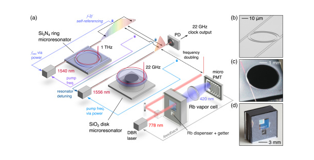
Contents
YouTube search... ...Google search
- Case Studies
- Autonomous Drones
- Deepmind teaches AI to follow navigational directions like humans | Tristan Greene
- History of Navigation | Wikipedia
- Navigation Aids | Department of Transportation, Federal Aviation Administration
- VN-300 | Vectornav ...miniature, high-performance Dual Antenna Global Navigation Satellite Systems (GNSS)-Aided Inertial Navigation System (INS) that combines micro-electromechanical systems (MEMS) inertial sensors, two high-sensitivity GNSS receivers, and advanced Kalman filtering algorithms to provide optimal estimates of position, velocity, and orientation.
Navigation is a field of study that focuses on the process of monitoring and controlling the movement of a craft or vehicle from one place to another.[1] The field of navigation includes four general categories: land navigation, marine navigation, aeronautic navigation, and space navigation. Navigation | Wikipedia
|
|
GPS: The Global Positioning System
YouTube search... ...Google search
- Man-made (artificial) Satellites
- GPS has been copied by Russia's GLONASS, Europe’s Galileo, China's BeiDou, India’s IRNSS, and Japan’s QZSS
- Artificial intelligence in GPS navigation systems | Jeffrey L. Duffany
- RoadTagger: GPS system upgrade utilizes AI to make sure you're in the right lane | David Nield - New Atlas ...Artificial intelligence to update digital maps and improve GPS navigation | Amit Malewar - InceptiveMind
- GPS.gov
- Inside GNSS ...Global Navigation Satellite Systems
- Navstar | Space.com ...is a network of U.S. satellites that provide GPS services
- SpaceX launches third-generation GPS navigation satellite | CBS News ...GPS-3 satellite — the fourth in a series of more powerful third-generation navigation stations built by Lockheed Martin — was expected to be deployed about a 90 minutes after liftoff. Assuming tests and checkout go well, it will join a globe-spanning constellation of 31 GPS satellites.
- Air Force asks three U.S. contractors to develop miniature ASIC technology for next-gen GPS receivers | John Keller - Military & Aerospace Electronics ...small low-power-consumption GPS enabling technologies to include a next-generation ASIC for secure GPS land navigation.
- China Launches Beidou, Its Own Version of GPS | Andrew Jones - IEEE Spectrum ...China places the final Beidou navigation system satellite into orbit
- There’s no GPS in outer space
- NASA is Making An AI-Based GPS For Space | Kristin Houser
- Frontier Development Lab (FDL) ...Artificial Intelligence Research for Space Science, Exploration & All Humankind
GPS receivers that use the L5 band can pinpoint to within 30 centimeters or 11.8 inches. The GPS concept is based on time and the known position of GPS specialized satellites. The satellites carry very stable atomic clocks that are synchronized with one another and with the ground clocks. Any drift from time maintained on the ground is corrected daily. In the same manner, the satellite locations are known with great precision. GPS receivers have clocks as well, but they are less stable and less precise. Each GPS satellite continuously transmits a radio signal containing the current time and data about its position. Since the speed of radio waves is constant and independent of the satellite speed, the time delay between when the satellite transmits a signal and the receiver receives it is proportional to the distance from the satellite to the receiver. A GPS receiver monitors multiple satellites and solves equations to determine the precise position of the receiver and its deviation from true time. At a minimum, four satellites must be in view of the receiver for it to compute four unknown quantities (three position coordinates and clock deviation from satellite time). Global Positioning System | Wikipedia
|
|
|
|
|
|
|
|
|
|
YouTube search... ...Google search
- Cybersecurity
- Tactical Radio (TR) A-PNT Overview | COL Daniel F. Kuntz, USA - TRADOC Capabilities Manager Tactical Radios (TCM TR) - U.S. Army Cyber Center of Excellence & Fort Gordon
- A-PNT: Assured Position, Navigation and Timing | Curtiss-Wright
- China tipped to 'wipe out' GPS with 'dire consequences' after conflict catalyst exposed | Callum Hoare - The Daily Express ...China could bring the world to its knees by "wiping out" GPS, a key system used by the US military and its NATO allies, an expert on space policy has told Express.co.uk GPS Unreliability | Dennis L. Bryant - MarineLink
Like the GPS units in many automobiles today, a simple receiver and some processing power is all that is needed for accurate navigation. But, what if the GPS satellites suddenly became unavailable due to malfunction, enemy action or simple interference, such as driving into a tunnel? Unavailability of GPS would be inconvenient for drivers on the road, but could be disastrous for military missions. Extreme Miniaturization: Seven Devices, One Chip to Navigate without GPS | US Defense Advanced Research Projects Agency (DARPA)
|
|
|
|
|
|
|
|
|
|
|
|
Geolocation: Locating GPS/GNSS Jamming and Spoofing
YouTube search... ...Google search
|
|
|
|
YouTube search... ...Google search
|
|
YouTube search... ...Google search
YouTube search... ...Google search
- UK Research and Innovation
- Review of Quantum Navigation | Donghui Feng - IOP Conference Series: Earth and Environmental Science
- Quantum Sensing Technology Growing Rapidly to Enable Ultra Sensitive Quantum RADARS, Imaging, and Navigation | Rajesh Uppal - International Defence Security & Technology
Typically, the performance of measurement devices is limited by deleterious effects such as thermal noise and vibration. Notable exceptions are atomic clocks, which operate very near their fundamental limits. Driving devices to their physical limits will open new application spaces critical to future DoD systems. Indeed, many defense-critical applications already require exceptionally precise time and frequency standards enabled only by atomic clocks. The Global Positioning System (GPS) and the internet are two key examples. Measurement systems based on atomic physics benefit from the exquisite properties of the atom. Among these are (a) precise frequency transitions, (b) the ability to initialize, control, and readout the atomic state and (c) environmental isolation. In addition, atomic properties are absolute, and do not “drift” over time. In this sense, atoms are self-calibrated, making them ideal for precision sensing. Quantum-Assisted Sensing and Readout (QuASAR) | US Defense Advanced Research Projects Agency (DARPA)
Time & Music
YouTube search... ...Google search
