Difference between revisions of "Time"
m (→Assured-Positioning, Navigation and Timing (A-PNT)) |
m |
||
| (47 intermediate revisions by the same user not shown) | |||
| Line 8: | Line 8: | ||
[http://www.google.com/search?q=clock+time+keeping+artificial+intelligence+ai ...Google search] | [http://www.google.com/search?q=clock+time+keeping+artificial+intelligence+ai ...Google search] | ||
| + | * [[Cybersecurity: National Institute of Standards and Technology (NIST) & U.S. Department of Homeland Security (DHS)]] | ||
| + | ** [http://www.nist.gov/pml/time-and-frequency-division Time and Frequency Division, Physical Measurement Laboratory, National Institute of Standards and Technology (NIST)] | ||
| + | ** [http://www.npl.co.uk/ntc National Timing Centre] ... Assured Time and Frequency for the UK | ||
* [http://en.wikipedia.org/wiki/Time Time] ...[http://en.wikipedia.org/wiki/Coordinated_Universal_Time Coordinated Universal Time UTC] ... [http://en.wikipedia.org/wiki/Clock Clock] ...[http://en.wikipedia.org/wiki/History_of_timekeeping_devices Timekeeping | Wikipedia] | * [http://en.wikipedia.org/wiki/Time Time] ...[http://en.wikipedia.org/wiki/Coordinated_Universal_Time Coordinated Universal Time UTC] ... [http://en.wikipedia.org/wiki/Clock Clock] ...[http://en.wikipedia.org/wiki/History_of_timekeeping_devices Timekeeping | Wikipedia] | ||
* [http://interestingengineering.com/the-very-long-and-fascinating-history-of-clocks The Very Long and Fascinating History of Clocks | Christopher McFadden - Interesting Engineering] | * [http://interestingengineering.com/the-very-long-and-fascinating-history-of-clocks The Very Long and Fascinating History of Clocks | Christopher McFadden - Interesting Engineering] | ||
| + | ** [http://www.youtube.com/watch?v=t-_VPRCtiUg The Surprising Secret of Synchronization | Veritasium] | ||
* [http://www.timeanddate.com/time/leapseconds.html What Is a Leap Second? | Konstantin Bikos and Anne Buckle - timeanddate.com] | * [http://www.timeanddate.com/time/leapseconds.html What Is a Leap Second? | Konstantin Bikos and Anne Buckle - timeanddate.com] | ||
* [http://www.amazon.com/s?k=atomic+clock&ref=nb_sb_noss_1 Atomic clocks] ...[http://www.amazon.com/s?k=tide+clock&ref=nb_sb_noss_1 Tide Clock | ][[Amazon]] | * [http://www.amazon.com/s?k=atomic+clock&ref=nb_sb_noss_1 Atomic clocks] ...[http://www.amazon.com/s?k=tide+clock&ref=nb_sb_noss_1 Tide Clock | ][[Amazon]] | ||
| + | ** [http://www.sciencenews.org/article/atomic-clock-general-relativity-time-warp-millimeter-physics An atomic clock measured how general relativity warps time across a millimeter | Emily Conover - ScienceNews] | ||
| + | * [http://en.wikipedia.org/wiki/Clock_synchronization Clock synchronization] | ||
* [http://primo.ai/index.php?title=Cybersecurity Cybersecurity] | * [http://primo.ai/index.php?title=Cybersecurity Cybersecurity] | ||
** [http://www.crownsterling.io/ Crown Sterling] ... changing the face of digital security with its non-integer-based algorithms that leverage time, AI and irrational numbers. | ** [http://www.crownsterling.io/ Crown Sterling] ... changing the face of digital security with its non-integer-based algorithms that leverage time, AI and irrational numbers. | ||
| Line 47: | Line 53: | ||
The Earth's rotation is so accurate it varies only in milliseconds ...do you feel the Earth rotation slowing down? | The Earth's rotation is so accurate it varies only in milliseconds ...do you feel the Earth rotation slowing down? | ||
| + | |||
| + | |||
| + | <i>[http://iohk.io/en/blog/posts/2021/10/27/ouroboros-chronos-provides-the-first-high-resilience-cryptographic-time-source-based-on-blockchain/ Time is an indispensable concept within computer programs and applications. Without this concept, we would not be able to access any transport layer security (TLS) based websites, exchange data, or utilize various cryptographic algorithms. | Olga Hryniuk - Input Output] </i> | ||
| Line 157: | Line 166: | ||
|}<!-- B --> | |}<!-- B --> | ||
| − | = <span id="Navigation | + | = <span id="Positioning, Navigation and Timing (PNT)"></span>Positioning, Navigation and Timing (PNT) = |
[http://www.youtube.com/results?search_query=Navigation+positioning+Aid+radar+waves+artificial+intelligence+ai YouTube search...] | [http://www.youtube.com/results?search_query=Navigation+positioning+Aid+radar+waves+artificial+intelligence+ai YouTube search...] | ||
[http://www.google.com/search?q=Navigation+positioning+Aid+radar+waves+artificial+intelligence+ai ...Google search] | [http://www.google.com/search?q=Navigation+positioning+Aid+radar+waves+artificial+intelligence+ai ...Google search] | ||
| Line 172: | Line 181: | ||
* [http://thenextweb.com/artificial-intelligence/2019/03/04/deepmind-teaches-ai-to-follow-navigational-directions-like-humans/ Deepmind teaches AI to follow navigational directions like humans | Tristan Greene] | * [http://thenextweb.com/artificial-intelligence/2019/03/04/deepmind-teaches-ai-to-follow-navigational-directions-like-humans/ Deepmind teaches AI to follow navigational directions like humans | Tristan Greene] | ||
* [http://en.wikipedia.org/wiki/History_of_navigation History of Navigation | Wikipedia] | * [http://en.wikipedia.org/wiki/History_of_navigation History of Navigation | Wikipedia] | ||
| − | ** [http://www.amazon.com/Longitude-Genius-Greatest-Scientific-Problem/dp/080271529X/ref=sr_1_1?crid=3KYYCAGJ2JJD6 Longitude: The True Story of a Lone Genius Who Solved the Greatest Scientific Problem of His Time | Dava Sobel][[Amazon]] ...[http://tpplayer-video-featured-snippets.googleusercontent.com/player.html?video=x2z5wg8&start=0&end=70 Video: "Lost at Sea: The Search for Longitude"] [http://www.pbs.org/wgbh/nova/longitude/ Nova companion Web site] | + | ** [http://www.amazon.com/Longitude-Genius-Greatest-Scientific-Problem/dp/080271529X/ref=sr_1_1?crid=3KYYCAGJ2JJD6 Longitude: The True Story of a Lone Genius Who Solved the Greatest Scientific Problem of His Time | Dava Sobel][[Amazon]] ...[http://tpplayer-video-featured-snippets.googleusercontent.com/player.html?video=x2z5wg8&start=0&end=70 Video: "Lost at Sea: The Search for Longitude"] [http://www.pbs.org/wgbh/nova/longitude/ Nova companion Web site] |
| + | * [http://www.dhs.gov/science-and-technology/pnt-program Department of Homeland Security (DHS) Science and Technology (S&T) Positioning, Navigation, and Timing (PNT) Program] | ||
* [http://www.faa.gov/air_traffic/publications/atpubs/aim_html/chap1_section_1.html Navigation Aids | Department of Transportation, Federal Aviation Administration] | * [http://www.faa.gov/air_traffic/publications/atpubs/aim_html/chap1_section_1.html Navigation Aids | Department of Transportation, Federal Aviation Administration] | ||
* [http://www.vectornav.com/products/vn-200 VN-300 | Vectornav] ...miniature, high-performance Dual Antenna Global Navigation Satellite Systems (GNSS)-Aided Inertial Navigation System (INS) that combines micro-electromechanical systems (MEMS) inertial sensors, two high-sensitivity GNSS receivers, and advanced Kalman filtering algorithms to provide optimal estimates of position, velocity, and orientation. | * [http://www.vectornav.com/products/vn-200 VN-300 | Vectornav] ...miniature, high-performance Dual Antenna Global Navigation Satellite Systems (GNSS)-Aided Inertial Navigation System (INS) that combines micro-electromechanical systems (MEMS) inertial sensors, two high-sensitivity GNSS receivers, and advanced Kalman filtering algorithms to provide optimal estimates of position, velocity, and orientation. | ||
| Line 194: | Line 204: | ||
</b><br>How did Planes Fly Before GPS?: | </b><br>How did Planes Fly Before GPS?: | ||
The Wright Brothers first took to the skies in 1903 but GPS wasn't publicly available until 1983, so how did planes traverse the world in those 80 years? From celestial navigation to dead reckoning, to the firsts forms of radio telemetry (like adock range stations and LORAN) we'll be discussing them all in this video. Discord: http://discord.gg/DUvyS8n Amazon Affiliate Link*: http://amzn.to/3kNTHhK | The Wright Brothers first took to the skies in 1903 but GPS wasn't publicly available until 1983, so how did planes traverse the world in those 80 years? From celestial navigation to dead reckoning, to the firsts forms of radio telemetry (like adock range stations and LORAN) we'll be discussing them all in this video. Discord: http://discord.gg/DUvyS8n Amazon Affiliate Link*: http://amzn.to/3kNTHhK | ||
| + | |} | ||
| + | |}<!-- B --> | ||
| + | {|<!-- T --> | ||
| + | | valign="top" | | ||
| + | {| class="wikitable" style="width: 550px;" | ||
| + | || | ||
| + | <youtube>nEtOmNrxwoU</youtube> | ||
| + | <b>PNT Requirements Definition – Some Principles with John Pottle | ||
| + | </b><br>Royal Institute of Navigation. Presenter: John Pottle, Director of the Royal Institute of Navigation | ||
| + | |} | ||
| + | |<!-- M --> | ||
| + | | valign="top" | | ||
| + | {| class="wikitable" style="width: 550px;" | ||
| + | || | ||
| + | <youtube>NN1pc28cpVI</youtube> | ||
| + | <b>Hosted PNT as a Service (PNTaaS) | ||
| + | </b><br>NAVSYS Corporation. The threat to GPS drives demand for a back-up position, navigation, and timing (PNT) solution that can operate in the event of denial of service to the GPS satellite signals. The military is dependent on PNT for their warfighting operations, and national critical infrastructure is also reliant on GPS for positioning and timing. In this video, we describe our PNT as a Service (PNTaaS) concept that will leverage capabilities already existing on certain commercial broadband internet satellite constellations to allow their signals to be used for PNT. | ||
|} | |} | ||
|}<!-- B --> | |}<!-- B --> | ||
| Line 205: | Line 232: | ||
* [http://ieeexplore.ieee.org/document/5608862 Artificial intelligence in GPS navigation systems | Jeffrey L. Duffany] | * [http://ieeexplore.ieee.org/document/5608862 Artificial intelligence in GPS navigation systems | Jeffrey L. Duffany] | ||
* RoadTagger: [http://newatlas.com/technology/gps-system-ai-upgrade/ GPS system upgrade utilizes AI to make sure you're in the right lane | David Nield - New Atlas] ...[http://www.inceptivemind.com/artificial-intelligence-roadtagger-digital-maps-improve-gps-navigation/11525/ Artificial intelligence to update digital maps and improve GPS navigation | Amit Malewar - InceptiveMind] | * RoadTagger: [http://newatlas.com/technology/gps-system-ai-upgrade/ GPS system upgrade utilizes AI to make sure you're in the right lane | David Nield - New Atlas] ...[http://www.inceptivemind.com/artificial-intelligence-roadtagger-digital-maps-improve-gps-navigation/11525/ Artificial intelligence to update digital maps and improve GPS navigation | Amit Malewar - InceptiveMind] | ||
| − | * [http://www.gps.gov/ GPS.gov] | + | * [http://www.gps.gov/ GPS.gov] ...[http://www.gps.gov/applications/timing/ Timing] |
* [http://insidegnss.com/ Inside GNSS] ...Global Navigation Satellite Systems | * [http://insidegnss.com/ Inside GNSS] ...Global Navigation Satellite Systems | ||
* [http://www.space.com/19794-navstar.html Navstar | Space.com] ...is a network of U.S. satellites that provide GPS services | * [http://www.space.com/19794-navstar.html Navstar | Space.com] ...is a network of U.S. satellites that provide GPS services | ||
| Line 230: | Line 257: | ||
<youtube>aDWbpRXblMk</youtube> | <youtube>aDWbpRXblMk</youtube> | ||
<b>Satellite Navigation Systems Overview with John Pottle | <b>Satellite Navigation Systems Overview with John Pottle | ||
| − | </b><br>Royal Institute of Navigation John Pottle, Director of the Royal Institute of Navigation, will put into context what the hundreds of navigation satellites in space are all for and how they work together. This webinar will explain the similarities and differences between global and regional satellite navigation systems, how they are co-ordinated, and by whom. The space-based augmentation systems will also be covered: what are these and how do they help? *During the webinar Q&A there was a question about whether or not GNSS could be used for moon missions - please see: Website: http://rin.org.uk/ | + | </b><br>Royal Institute of Navigation. John Pottle, Director of the Royal Institute of Navigation, will put into context what the hundreds of navigation satellites in space are all for and how they work together. This webinar will explain the similarities and differences between global and regional satellite navigation systems, how they are co-ordinated, and by whom. The space-based augmentation systems will also be covered: what are these and how do they help? *During the webinar Q&A there was a question about whether or not GNSS could be used for moon missions - please see: Website: http://rin.org.uk/ |
|} | |} | ||
|}<!-- B --> | |}<!-- B --> | ||
| Line 302: | Line 329: | ||
|}<!-- B --> | |}<!-- B --> | ||
| − | + | == <span id="Jamming and Spoofing"></span>Jamming and Spoofing == | |
| − | |||
[http://www.youtube.com/results?search_query=Jamming+Spoofing+Positioning+Navigation+Timing+PNT+GPS+GNSS+GB-GRAM+INS+CSAC+artificial+intelligence+ai YouTube search...] | [http://www.youtube.com/results?search_query=Jamming+Spoofing+Positioning+Navigation+Timing+PNT+GPS+GNSS+GB-GRAM+INS+CSAC+artificial+intelligence+ai YouTube search...] | ||
[http://www.google.com/search?q=Jamming+Spoofing+Positioning+Navigation+Timing+PNT+GPS+GNSS+GB-GRAM+INS+CSAC+artificial+intelligence+ai ...Google search] | [http://www.google.com/search?q=Jamming+Spoofing+Positioning+Navigation+Timing+PNT+GPS+GNSS+GB-GRAM+INS+CSAC+artificial+intelligence+ai ...Google search] | ||
| + | |||
| + | * [http://RNTFnd.org/ The Resilient Navigation and Timing Foundation] | ||
| + | ** [http://rntfnd.org/wp-content/uploads/Multi-LayerFinal.jpg Multi‐level resiliency model] | ||
| + | ** [http://rntfnd.org/2020/11/27/china-research-paper-on-differential-eloran-sensors-journal/ China Research Paper on Differential eLoran – Sensors Journal] | ||
| + | ** [http://rntfnd.org/wp-content/uploads/Resilient-National-Timing-Architecture-16-Oct-2020.pdf A Resilient National Timing Architecture – 16 October 2020] | ||
| + | ** [http://rntfnd.org/2020/12/05/gps-jamming-spoofing-2020-year-in-review-spirents-guy-buesnel/ GPS Jamming & Spoofing, 2020 Year in Review – Spirent’s Guy Buesnel] | ||
| + | ** [http://rntfnd.org/2021/06/05/the-russia-trap-single-points-of-failure-gps/ “The Russia Trap” – Single Points of Failure & GPS | Blog Editor / George Beebe] | ||
| + | * [http://www.dhs.gov/publication/st-resilient-pnt-conformance-framework Department of Homeland Security (DHS) Science and Technology (S&T) Resilient Positioning, Navigation, and Timing (PNT) Conformance Framework] | ||
| + | * [http://www.forbes.com/sites/steveforbes/2020/11/13/the-space-force-a-conversation-with-united-states-secretary-of-the-air-force-barbara-barrett/?sh=61d1c90a41fa The Space Force: A Conversation With United States Secretary Of The Air Force Barbara Barrett | Steve Forbes - Forbes] ... We are vulnerable. For example, the U.S. and the global economy are totally dependent on satellites, most especially the GPS, which is operated by the Space Force. | ||
| + | |||
{|<!-- T --> | {|<!-- T --> | ||
| Line 323: | Line 359: | ||
|} | |} | ||
|}<!-- B --> | |}<!-- B --> | ||
| − | + | {|<!-- T --> | |
| + | | valign="top" | | ||
| + | {| class="wikitable" style="width: 550px;" | ||
| + | || | ||
| + | <youtube>f-tVx5DuoLs</youtube> | ||
| + | <b>Orolia Presents: GPS World Webinar – Resilient PNT for a 5G World | ||
| + | </b><br>Panelists will discuss key factors for the successful implementation of 5G technology for 5G infrastructures, automotive, and mission critical applications: | ||
| + | - Testing requirements needed to ensure consistent operations | ||
| + | - Resilient Positioning, Navigation and Timing (PNT) technologies that can help ensure accurate, continuous operations for critical applications during interference or signal loss. | ||
| + | |<!-- M --> | ||
| + | | valign="top" | | ||
| + | {| class="wikitable" style="width: 550px;" | ||
| + | || | ||
| + | <youtube>T6YS7gMJCUc</youtube> | ||
| + | <b>Which is the bigger problem? Risk assessment for PNT with Dana Goward | ||
| + | </b><br>This webinar is part of the Resilient Positioning Navigation and Timing Seminar Series. Find out more about this series at: https://rin.org.uk/events/EventDetail... Presenter: Dana Goward, President & Director, Resilient Navigation and Timing Foundation | ||
| + | |} | ||
| + | |}<!-- B --> | ||
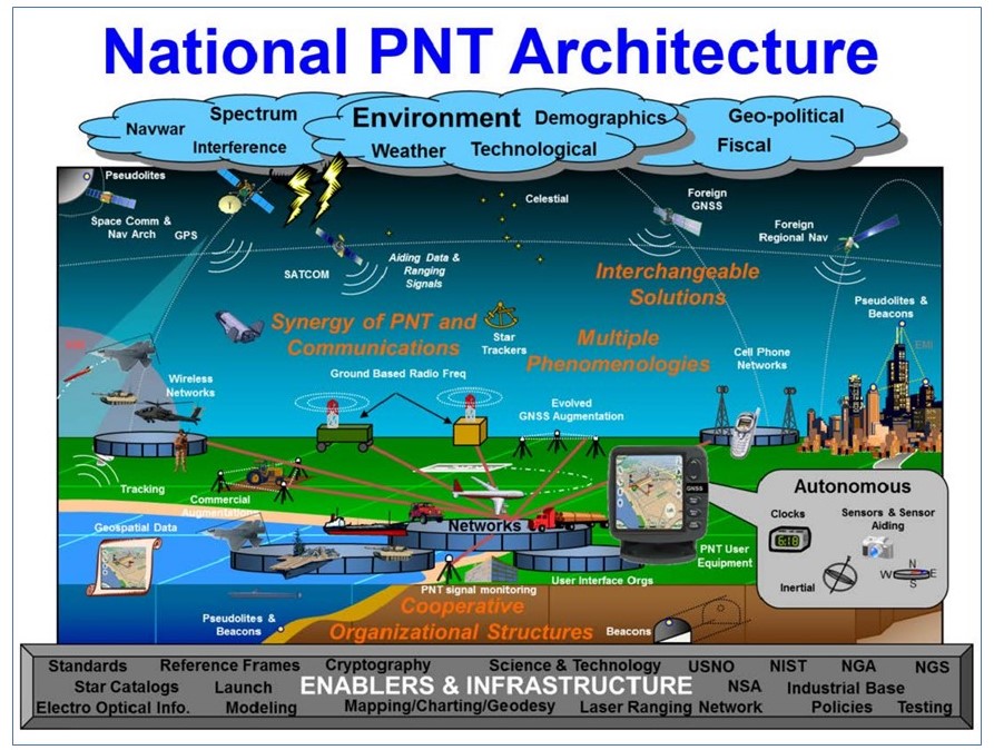
=== <span id="Assured-Positioning, Navigation and Timing (A-PNT)"></span>Assured-Positioning, Navigation and Timing (A-PNT) === | === <span id="Assured-Positioning, Navigation and Timing (A-PNT)"></span>Assured-Positioning, Navigation and Timing (A-PNT) === | ||
| Line 330: | Line 383: | ||
* [[Cybersecurity]] | * [[Cybersecurity]] | ||
| − | * [http://www.youtube.com/watch?v=NCOcliI-nkM Tactical Radio (TR) A-PNT Overview | COL Daniel F. Kuntz, USA - TRADOC Capabilities Manager Tactical Radios (TCM TR) - U.S. Army Cyber Center of Excellence & Fort Gordon] | + | * [http://www.esd.whs.mil/Portals/54/Documents/DD/issuances/dodi/465008p.pdf DOD INSTRUCTION 4650.08 Positioning, Navigation and Timing Warfare] |
| + | ** [http://www.gao.gov/products/gao-21-320sp DOD is Developing Positioning, Navigation, and Timing Technologies to Complement GPS | GAO] DOD is pursuing approaches, such as creating common standards and interfaces, to aid in integrating and fielding new PNT technologies faster and at lower cost. DOD is developing its PNT modeling and simulation capabilities to evaluate the performance of new PNT technologies. | ||
| + | ** [http://www.youtube.com/watch?v=NCOcliI-nkM Tactical Radio (TR) A-PNT Overview | COL Daniel F. Kuntz, USA - TRADOC Capabilities Manager Tactical Radios (TCM TR) - U.S. Army Cyber Center of Excellence & Fort Gordon] | ||
| + | * [http://apps.dtic.mil/sti/pdfs/ADA494614.pdf National Positioning, Navigation, and Timing Architecture | Lt Col Patrick Huested, USAF National Security Space Office and Paul D. Popejoy The Aerospace Corporation] | ||
| + | * [http://rntfnd.org/wp-content/uploads/Resilient-National-Timing-Architecture-16-Oct-2020.pdf A Resilient National Timing Architecture: Securing Today's, Enabling Tomorrow's | Dr. Marc Weiss, Dr. Patrick Diamond, and Mr. Dana A. Goward] | ||
| + | |||
* [http://www.curtisswrightds.com/technologies/open-architecture/assured-position-navigation-timing.html A-PNT: Assured Position, Navigation and Timing | Curtiss-Wright] | * [http://www.curtisswrightds.com/technologies/open-architecture/assured-position-navigation-timing.html A-PNT: Assured Position, Navigation and Timing | Curtiss-Wright] | ||
* [http://www.express.co.uk/news/science/1358337/china-vs-us-beijing-wipe-out-gps-space-conflict-moon-mars-satellite-taiwan-joe-biden-spt China tipped to 'wipe out' GPS with 'dire consequences' after conflict catalyst exposed | Callum Hoare - The Daily Express] ...[[Government Services#China|China]] could bring the world to its knees by "wiping out" GPS, a key system used by the US military and its NATO allies, an expert on space policy has told Express.co.uk [http://www.marinelink.com/news/gps-unreliability-483109 GPS Unreliability | Dennis L. Bryant - MarineLink] | * [http://www.express.co.uk/news/science/1358337/china-vs-us-beijing-wipe-out-gps-space-conflict-moon-mars-satellite-taiwan-joe-biden-spt China tipped to 'wipe out' GPS with 'dire consequences' after conflict catalyst exposed | Callum Hoare - The Daily Express] ...[[Government Services#China|China]] could bring the world to its knees by "wiping out" GPS, a key system used by the US military and its NATO allies, an expert on space policy has told Express.co.uk [http://www.marinelink.com/news/gps-unreliability-483109 GPS Unreliability | Dennis L. Bryant - MarineLink] | ||
Like the GPS units in many automobiles today, a simple receiver and some processing power is all that is needed for accurate navigation. But, what if the GPS satellites suddenly became unavailable due to malfunction, enemy action or simple interference, such as driving into a tunnel? Unavailability of GPS would be inconvenient for drivers on the road, but could be disastrous for military missions. [http://www.darpa.mil/news-events/2013-04-10 Extreme Miniaturization: Seven Devices, One Chip to Navigate without GPS | ] [[Defense#US Defense Advanced Research Projects Agency (DARPA)|US Defense Advanced Research Projects Agency (DARPA)]] | Like the GPS units in many automobiles today, a simple receiver and some processing power is all that is needed for accurate navigation. But, what if the GPS satellites suddenly became unavailable due to malfunction, enemy action or simple interference, such as driving into a tunnel? Unavailability of GPS would be inconvenient for drivers on the road, but could be disastrous for military missions. [http://www.darpa.mil/news-events/2013-04-10 Extreme Miniaturization: Seven Devices, One Chip to Navigate without GPS | ] [[Defense#US Defense Advanced Research Projects Agency (DARPA)|US Defense Advanced Research Projects Agency (DARPA)]] | ||
| + | |||
| + | <img src="http://rntfnd.org/wp-content/uploads/National-PNT-Architecture.jpg" width="1000"> | ||
| + | |||
| + | [http://cms7.dot.gov/pnt/national-positioning-navigation-and-timing-pnt-architecture National Positioning, Navigation, and Timing (PNT) Architecture | U.S. Department of Transportation] | ||
| + | |||
{|<!-- T --> | {|<!-- T --> | ||
| Line 340: | Line 403: | ||
{| class="wikitable" style="width: 550px;" | {| class="wikitable" style="width: 550px;" | ||
|| | || | ||
| − | <youtube> | + | <youtube>rDplstBfxp0</youtube> |
| − | <b> | + | <b>System Performance and Resilience or: What could possibly go wrong? with Prof Marek Ziebart |
| − | </b><br>Royal Institute of Navigation | + | </b><br>Royal Institute of Navigation. Presenter: Prof Marek Ziebart, Director, Space Geodesy and Navigation Group, University College London Website: http://rin.org.uk/ |
|} | |} | ||
|<!-- M --> | |<!-- M --> | ||
| Line 362: | Line 425: | ||
<youtube>5T6v1HK-a6s</youtube> | <youtube>5T6v1HK-a6s</youtube> | ||
<b>When GNSS fails, what will you do? - MarRINav! | <b>When GNSS fails, what will you do? - MarRINav! | ||
| − | </b><br>This webinar, called 'When GNSS fails, what will you do? - MarRINav! ' features presentations and comments form Jonathan Turner (NLA Int.), Dr Alan Grant (GLA), and Dana Goward (RNTF). The webinar provides analysis and insights from Phase 1 of the Maritime Resilience and Integrity of Navigation (MarRINav) project. To download the full transcript of Jonathan's presentation please follow this link: https://rin.org.uk/resource/resmgr/fi... Many thanks to all co-sponsors of this webinar: Resilient Navigation and Timing Foundation, Institute of Navigation, GPS World, The Maritime Executive, and of course the MarRINav project. Website: http://rin.org.uk/ | + | </b><br>Royal Institute of Navigation. This webinar, called 'When GNSS fails, what will you do? - MarRINav! ' features presentations and comments form Jonathan Turner (NLA Int.), Dr Alan Grant (GLA), and Dana Goward (RNTF). The webinar provides analysis and insights from Phase 1 of the Maritime Resilience and Integrity of Navigation (MarRINav) project. To download the full transcript of Jonathan's presentation please follow this link: https://rin.org.uk/resource/resmgr/fi... Many thanks to all co-sponsors of this webinar: Resilient Navigation and Timing Foundation, Institute of Navigation, GPS World, The Maritime Executive, and of course the MarRINav project. Website: http://rin.org.uk/ |
|} | |} | ||
|<!-- M --> | |<!-- M --> | ||
| Line 379: | Line 442: | ||
<youtube>WDATFeVTUHs</youtube> | <youtube>WDATFeVTUHs</youtube> | ||
<b>Enabling the Next Generation of GPS Technology with Supercorrelation with Dr Ramsey Faragher | <b>Enabling the Next Generation of GPS Technology with Supercorrelation with Dr Ramsey Faragher | ||
| − | </b><br>Royal Institute of Navigation Focal Point Positioning have developed a new method for processing GNSS radio signals called Supercorrelation which dramatically improves the performance of the earliest stage of radio processing. The software update removes multipath interference at the correlator level, and provides the ability to determine signal arrival angle without adding any new hardware to a standard GNSS device. In this webinar Dr Ramsey Faragher, Founder/CEO of FocalPoint will explain how the technology works, will cover some of the challenges that FocalPoint have overcome in deploying it on very low cost platforms, and will show off the new capabilities that it unlocks. Website: http://rin.org.uk/ | + | </b><br>Royal Institute of Navigation. Focal Point Positioning have developed a new method for processing GNSS radio signals called Supercorrelation which dramatically improves the performance of the earliest stage of radio processing. The software update removes multipath interference at the correlator level, and provides the ability to determine signal arrival angle without adding any new hardware to a standard GNSS device. In this webinar Dr Ramsey Faragher, Founder/CEO of FocalPoint will explain how the technology works, will cover some of the challenges that FocalPoint have overcome in deploying it on very low cost platforms, and will show off the new capabilities that it unlocks. Website: http://rin.org.uk/ |
|} | |} | ||
|<!-- M --> | |<!-- M --> | ||
| Line 422: | Line 485: | ||
<youtube>AOlZMw_secI</youtube> | <youtube>AOlZMw_secI</youtube> | ||
<b>Securing Positioning & Timing 7: Improving Performance by Augmenting GPS/GNSS | <b>Securing Positioning & Timing 7: Improving Performance by Augmenting GPS/GNSS | ||
| − | </b><br>Royal Institute of Navigation The seventh, and final, of a series of webinars from the Securing Positioning & Timing short course. This webinar covers Improving Performance by Augmenting GPS/GNSS. Presented by Prof Terry Moore. Supported by the UK Space Agency. Website: http://rin.org.uk/ | + | </b><br>Royal Institute of Navigation. The seventh, and final, of a series of webinars from the Securing Positioning & Timing short course. This webinar covers Improving Performance by Augmenting GPS/GNSS. Presented by Prof Terry Moore. Supported by the UK Space Agency. Website: http://rin.org.uk/ |
| + | |} | ||
| + | |}<!-- B --> | ||
| + | {|<!-- T --> | ||
| + | | valign="top" | | ||
| + | {| class="wikitable" style="width: 550px;" | ||
| + | || | ||
| + | <youtube>BY-FYs4rxek</youtube> | ||
| + | <b>Assess performance & reduce risks across a multisensor, multi-system integration with Peter Rylands | ||
| + | </b><br>Royal Institute of Navigation. Presenter: Peter Rylands, Product Manager, Oxford Technical Solutions Ltd | ||
| + | |} | ||
| + | |<!-- M --> | ||
| + | | valign="top" | | ||
| + | {| class="wikitable" style="width: 550px;" | ||
| + | || | ||
| + | <youtube>vDnL_Ij3jes</youtube> | ||
| + | <b>Resilient PNT for Unmanned Systems | ||
| + | </b><br>Orolia. Demand for unmanned systems is growing exponentially across defense and civil/commercial organizations, for applications ranging from military missions and intelligence surveillance to border security and precision agriculture. | ||
| + | |||
| + | Resilient Positioning, Navigation and Timing (PNT) data and GPS/GNSS signals are critical for unmanned systems in order to successfully pilot and control aircraft, vehicle and vessel onboard systems. | ||
|} | |} | ||
|}<!-- B --> | |}<!-- B --> | ||
| Line 436: | Line 518: | ||
<youtube>lKnavLpgISc</youtube> | <youtube>lKnavLpgISc</youtube> | ||
<b>Securing Positioning & Timing 3: Detecting and Characterising GPS/GNSS Jamming & Spoofing | <b>Securing Positioning & Timing 3: Detecting and Characterising GPS/GNSS Jamming & Spoofing | ||
| − | </b><br>Royal Institute of Navigation The third of a series of webinars from the Securing Positioning & Timing short course. This webinar covers Detecting and Characterising GPS/GNSS Jamming & Spoofing. Presented by Dr Mark Dumville. Supported by the UK Space Agency. Website: http://rin.org.uk/ | + | </b><br>Royal Institute of Navigation. The third of a series of webinars from the Securing Positioning & Timing short course. This webinar covers Detecting and Characterising GPS/GNSS Jamming & Spoofing. Presented by Dr Mark Dumville. Supported by the UK Space Agency. Website: http://rin.org.uk/ |
|} | |} | ||
|<!-- M --> | |<!-- M --> | ||
| Line 444: | Line 526: | ||
<youtube>nQR8F4Hia2o</youtube> | <youtube>nQR8F4Hia2o</youtube> | ||
<b>Securing Positioning & Timing 4: Locating GPS/GNSS Jamming and Spoofing | <b>Securing Positioning & Timing 4: Locating GPS/GNSS Jamming and Spoofing | ||
| − | </b><br>Royal Institute of Navigation The fourth of a series of webinars from the Securing Positioning & Timing short course. This webinar covers Locating GPS/GNSS Jamming and Spoofing. Presented by Mike Jones. Supported by the UK Space Agency. Website: http://rin.org.uk/ | + | </b><br>Royal Institute of Navigation. The fourth of a series of webinars from the Securing Positioning & Timing short course. This webinar covers Locating GPS/GNSS Jamming and Spoofing. Presented by Mike Jones. Supported by the UK Space Agency. Website: http://rin.org.uk/ |
|} | |} | ||
|}<!-- B --> | |}<!-- B --> | ||
| Line 462: | Line 544: | ||
<b>Harris Corporation - Detect and Locate GPS Jamming with Signal Sentry™ 1000 | <b>Harris Corporation - Detect and Locate GPS Jamming with Signal Sentry™ 1000 | ||
</b><br>Harris Corporation The Global Positioning System—GPS—is an essential element of the global information infrastructure. GPS jamming devices are becoming cheaper and more accessible, creating a greater need to protect from a diverse range of threats. Harris Signal Sentry 1000 is a GPS interference detection and geolocation solution. It provides a web-based visualization tool to support timely and effective actionable intelligence. | </b><br>Harris Corporation The Global Positioning System—GPS—is an essential element of the global information infrastructure. GPS jamming devices are becoming cheaper and more accessible, creating a greater need to protect from a diverse range of threats. Harris Signal Sentry 1000 is a GPS interference detection and geolocation solution. It provides a web-based visualization tool to support timely and effective actionable intelligence. | ||
| + | |} | ||
| + | |}<!-- B --> | ||
| + | {|<!-- T --> | ||
| + | | valign="top" | | ||
| + | {| class="wikitable" style="width: 550px;" | ||
| + | || | ||
| + | <youtube>i6-tNzUIo0E</youtube> | ||
| + | <b>Why isn’t my GPS receiver consistently more accurate? with John Pottle | ||
| + | </b><br>Royal Institute of Navigation. Presenter: John Pottle, Director of the RIN Website: http://rin.org.uk/ | ||
| + | |} | ||
| + | |<!-- M --> | ||
| + | | valign="top" | | ||
| + | {| class="wikitable" style="width: 550px;" | ||
| + | || | ||
| + | <youtube>v-hDEJEsBso</youtube> | ||
| + | <b>Current threats to GNSS: An update of incidents and impacts with Guy Buesnel | ||
| + | </b><br>Royal Institute of Navigation. Presenter: Guy Buesnel, PNT Security Technologist Spirent Communications plc. Website: http://rin.org.uk/ | ||
|} | |} | ||
|}<!-- B --> | |}<!-- B --> | ||
Revision as of 07:39, 13 May 2022
YouTube search... ...Google search
- Cybersecurity: National Institute of Standards and Technology (NIST) & U.S. Department of Homeland Security (DHS)
- Time and Frequency Division, Physical Measurement Laboratory, National Institute of Standards and Technology (NIST)
- National Timing Centre ... Assured Time and Frequency for the UK
- Time ...Coordinated Universal Time UTC ... Clock ...Timekeeping | Wikipedia
- The Very Long and Fascinating History of Clocks | Christopher McFadden - Interesting Engineering
- What Is a Leap Second? | Konstantin Bikos and Anne Buckle - timeanddate.com
- Atomic clocks ...Tide Clock | Amazon
- Clock synchronization
- Cybersecurity
- Crown Sterling ... changing the face of digital security with its non-integer-based algorithms that leverage time, AI and irrational numbers.
- Quantum cryptography ... the infosec industry looks to quantum cryptography and quantum key distribution (QKD)
- Time Series
- Models
- Transformer
- Generative Pre-trained Transformer (GPT)
- Attention Mechanism/Transformer Model
- Transformer-XL
- Sequence to Sequence (Seq2Seq)
- End-to-End Speech
- Neural Turing Machine
- Recurrent Neural Network (RNN)
- (Tree) Recursive Neural (Tensor) Network (RNTN)
- Temporal Difference (TD) Learning
- Time Series Forecasting - Statistical
- Time Series Forecasting - Deep Learning
- Spatial-Temporal Dynamic Network (STDN)
- Transformer
Whenever we have developed better clocks, we’ve learned something new about the world.
- Alexander Smith New Time Dilation Phenomenon Revealed: Timekeeping Theory Combines Quantum Clocks and Einstein’s Relativity - Dartmouth College
The Earth's rotation is so accurate it varies only in milliseconds ...do you feel the Earth rotation slowing down?
DARPA Making Progress on Miniaturized Atomic Clocks for Future PNT Applications | US Defense Advanced Research Projects Agency (DARPA)
|
|
|
|
|
|
|
|
|
|
Contents
YouTube search... ...Google search
- Case Studies
- Autonomous Drones
- Deepmind teaches AI to follow navigational directions like humans | Tristan Greene
- History of Navigation | Wikipedia
- Department of Homeland Security (DHS) Science and Technology (S&T) Positioning, Navigation, and Timing (PNT) Program
- Navigation Aids | Department of Transportation, Federal Aviation Administration
- VN-300 | Vectornav ...miniature, high-performance Dual Antenna Global Navigation Satellite Systems (GNSS)-Aided Inertial Navigation System (INS) that combines micro-electromechanical systems (MEMS) inertial sensors, two high-sensitivity GNSS receivers, and advanced Kalman filtering algorithms to provide optimal estimates of position, velocity, and orientation.
Navigation is a field of study that focuses on the process of monitoring and controlling the movement of a craft or vehicle from one place to another.[1] The field of navigation includes four general categories: land navigation, marine navigation, aeronautic navigation, and space navigation. Navigation | Wikipedia
|
|
|
|
Global Positioning System (GPS)
YouTube search... ...Google search
- Man-made (artificial) Satellites
- GPS has been copied by Russia's GLONASS, Europe’s Galileo, China's BeiDou, India’s IRNSS, and Japan’s QZSS
- Artificial intelligence in GPS navigation systems | Jeffrey L. Duffany
- RoadTagger: GPS system upgrade utilizes AI to make sure you're in the right lane | David Nield - New Atlas ...Artificial intelligence to update digital maps and improve GPS navigation | Amit Malewar - InceptiveMind
- GPS.gov ...Timing
- Inside GNSS ...Global Navigation Satellite Systems
- Navstar | Space.com ...is a network of U.S. satellites that provide GPS services
- SpaceX launches third-generation GPS navigation satellite | CBS News ...GPS-3 satellite — the fourth in a series of more powerful third-generation navigation stations built by Lockheed Martin — was expected to be deployed about a 90 minutes after liftoff. Assuming tests and checkout go well, it will join a globe-spanning constellation of 31 GPS satellites.
- Air Force asks three U.S. contractors to develop miniature ASIC technology for next-gen GPS receivers | John Keller - Military & Aerospace Electronics ...small low-power-consumption GPS enabling technologies to include a next-generation ASIC for secure GPS land navigation.
- China Launches Beidou, Its Own Version of GPS | Andrew Jones - IEEE Spectrum ...China places the final Beidou navigation system satellite into orbit
- Big News For ISRO! Indian Navigation System (IRNSS) Gets Approval By IMP For Global Operations | Smriti Chaudhary - The EurAsuan Times
GPS receivers that use the L5 band can pinpoint to within 30 centimeters or 11.8 inches. The GPS concept is based on time and the known position of GPS specialized satellites. The satellites carry very stable atomic clocks that are synchronized with one another and with the ground clocks. Any drift from time maintained on the ground is corrected daily. In the same manner, the satellite locations are known with great precision. GPS receivers have clocks as well, but they are less stable and less precise. Each GPS satellite continuously transmits a radio signal containing the current time and data about its position. Since the speed of radio waves is constant and independent of the satellite speed, the time delay between when the satellite transmits a signal and the receiver receives it is proportional to the distance from the satellite to the receiver. A GPS receiver monitors multiple satellites and solves equations to determine the precise position of the receiver and its deviation from true time. At a minimum, four satellites must be in view of the receiver for it to compute four unknown quantities (three position coordinates and clock deviation from satellite time). Global Positioning System | Wikipedia
|
|
|
|
|
|
|
|
Deep-Space Positioning System (DPS)
YouTube search... ...Google search
- NASA is Making An AI-Based GPS For Space | Kristin Houser
- Frontier Development Lab (FDL) ...Artificial Intelligence Research for Space Science, Exploration & All Humankind
|
Jamming and Spoofing
YouTube search... ...Google search
- The Resilient Navigation and Timing Foundation
- Department of Homeland Security (DHS) Science and Technology (S&T) Resilient Positioning, Navigation, and Timing (PNT) Conformance Framework
- The Space Force: A Conversation With United States Secretary Of The Air Force Barbara Barrett | Steve Forbes - Forbes ... We are vulnerable. For example, the U.S. and the global economy are totally dependent on satellites, most especially the GPS, which is operated by the Space Force.
|